© Schlögener Schlinge (c) WGD Donau Oberösterreich Tourismus GmbH/GoodMorningWorld_MSchillinger
Schlögener Schlinge (c) WGD Donau Oberösterreich Tourismus GmbH/GoodMorningWorld_MSchillinger
search
Search
Close

Feldkirchen: Castle Loop Trail

  • Suitable for families
  • Flatly

 Interactive elevation profile

Download GPS data
Create PDF

Tour-Details

Path number: D21
Starting place: 4101 Feldkirchen an der Donau
Destination: 4101 Feldkirchen an der Donau

duration: 5h 45m
length: 20,7 km
Altitude difference (uphill): 175m
Altitude difference (downhill): 175m

Lowest point: 257m
Highest point: 432m
difficulty: medium
condition: medium
panoramic view: Great panorama

Paths covering:
Asphalt, Path / trail, Gravel, Other

powered by TOURDATA | Suggest a change

Short description:
Bergheim Castle - Feldkirchen – Feldkirchen lakes – Mühldorf Castle - Pesenbach - Bad Mühllacken – Pesenbachtal Valley – Prälatensteig Path
Quality of experience: *****

Recommended season:
  • April
  • May
  • June
  • July
  • August
  • September
  • October
Properties:
  • Loop
  • Refreshment stops available
  • Family friendly
  • Geological highlights
  • Botanical highlights

Description:

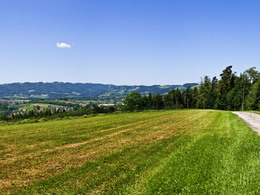
INTERESTING POINTS ALONG THE WAY:


Legendary cultural life:


  • Castles 

  • Kneipp herb garden


Nature (t)space & movement:


  • 4 Feldkirchen bathing lakes

  • Motor park

  • Pesenbach Valley


SPIRITUAL HIKING ON THE DONAUSTEIG:


BAD MÜHLACKEN


Once again we meet the Sisters of Mary of Mount Carmel, who run the traditional Kneipp spa, on the Donausteig. They are people who put their lives at the service of following Jesus.


The dynamic of withdrawing and committing oneself out of a listening heart is their guiding ...

Starting point: Feldkirchen / Oberlandshaag
Destination: Feldkirchen / Oberlandshaag

further information:
  • Flatly
  • Board possible

Accessibility / arrival

Public Transit
Bus: www.postbus.atParking
 direkt an der Donau in Oberlandshaag

Travelling by public transport
Route planner for independent travellers
Most economical season
  • Spring
  • Summer
  • Autumn

Please get in touch for more information.


Feldkirchen: Castle Loop Trail
Tourismusverein Feldkirchen an der Donau
Hauptstraße 1
4101 Feldkirchen an der Donau

mobile +43 664 5109060
E-Mail info@feldkirchenanderdonau.at
Web www.feldkirchenanderdonau.at
Web www.donauregion.at
https://www.feldkirchenanderdonau.at
http://www.donauregion.at

We speak the following languages

German

 Interactive elevation profile

Download GPS data
Create PDF

Tour-Details

Path number: D21
Starting place: 4101 Feldkirchen an der Donau
Destination: 4101 Feldkirchen an der Donau

duration: 5h 45m
length: 20,7 km
Altitude difference (uphill): 175m
Altitude difference (downhill): 175m

Lowest point: 257m
Highest point: 432m
difficulty: medium
condition: medium
panoramic view: Great panorama

Paths covering:
Asphalt, Path / trail, Gravel, Other

powered by TOURDATA | Suggest a change
Protected by