
© Schlögener Schlinge (c) WGD Donau Oberösterreich Tourismus GmbH/GoodMorningWorld_MSchillinger
 WGD Donau Oberösterreich Tourismus GmbH/GoodMorningWorld_MSchillinger")
 WGD Donau Oberösterreich Tourismus GmbH/GoodMorningWorld_MSchillinger")
R1.05 Sauwald Panorama Circuit


- Suitable for families
- Flatly
Interactive elevation profile
Create PDF
Tour-Details
Starting place: 4794 Kopfing im Innkreis
Destination: 4794 Kopfing im Innkreis
duration: 4h 19m
length: 57,9 km
Altitude difference (uphill): 802m
Altitude difference (downhill): 802m
Lowest point: 391m
Highest point: 628m
difficulty: medium
condition: medium
panoramic view: Dreamtour
Paths covering:
Asphalt
powered by TOURDATA | Suggest a change
Short description:
'Sauwald – Sublime cycling with Alpine views'
'Sauwald – Sublime cycling with Alpine views'
Technique: ***
Quality of experience: ******
Recommended season:
- March
- April
- May
- June
- July
- August
- September
- October
Properties:
Description:- Loop
- Scenic
- Refreshment stops available
- Family friendly
- Geological highlights
Fantastic highland cycle tour across the agricultural Sauwald high plateau. The rugged highlands to the south of the Upper Danube Valley inspire with mysterious woodlands, a mosaic of fields and meadows, traditional farming hamlets, an undulating landscape … and sheer endless views into the distance. The first half proceeds through a hilly landscape, the second across a panoramic mountain ridge.
Highlights:
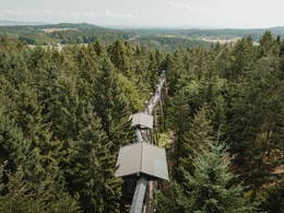
- Kopfing treetop trail (Longest treetop walk in the world, nature adventure world)
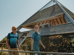
- Meditation pyramid on Etzinger Hill (architectural highlight, Alpine views)
- Sauwald panorama road ...
Starting point: Kopfing treetop trail / Kopfing – The starting point of circuit on the Danube Cycle Path is at the car park.
Destination: End point = Start point (Circular route)
further information:
- Flatly
- Board possible
")
")
")
")
")
Accessibility / arrival
Public Transit
Location and getting there
How to arrive in the Danube Upper Austrian region? The fast way to your destination – by train, bus, car, boat or plane.
Most economical season
- Spring
- Summer
- Autumn
Please get in touch for more information.
Lindengasse 9
4040 Linz
Phone +43 732 7277 - 800
Fax machine +43 732 7277 - 804
E-Mail info@donauregion.at
Web www.donauregion.at
http://www.donauregion.at
Interactive elevation profile
Create PDF
Tour-Details
Starting place: 4794 Kopfing im Innkreis
Destination: 4794 Kopfing im Innkreis
duration: 4h 19m
length: 57,9 km
Altitude difference (uphill): 802m
Altitude difference (downhill): 802m
Lowest point: 391m
Highest point: 628m
difficulty: medium
condition: medium
panoramic view: Dreamtour
Paths covering:
Asphalt
powered by TOURDATA | Suggest a change
R1.05 Sauwald Panorama Circuit
Suggest changes
Please let us know how we can improve the quality of this object or if there is any incorrect information on this page (eg. opening hours, contact, etc.).
Please fill in all fields marked *.