
R1.03 Donauengtal circuit


- Suitable for families
- culturally interesting
- Flatly
Interactive elevation profile
Create PDF
Tour-Details
Starting place: 4085 Waldkirchen am Wesen
Destination: 4085 Waldkirchen am Wesen
duration: 4h 9m
length: 57,3 km
Altitude difference (uphill): 696m
Altitude difference (downhill): 696m
Lowest point: 283m
Highest point: 659m
difficulty: medium
condition: medium
panoramic view: Dreamtour
Paths covering:
Asphalt
powered by TOURDATA | Suggest a change
Short description:
'Inspiring Danube gorge – river riding with views into the depths'
'Inspiring Danube gorge – river riding with views into the depths'
Technique: ***
Quality of experience: ******
Recommended season:
- March
- April
- May
- June
- July
- August
- September
- October
Properties:
Description:- Loop
- Scenic
- Refreshment stops available
- Family friendly
- Cultural/historical value
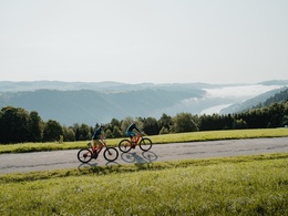
Upper Danube Valley - around 90 km in length, up to 300m deep, home to the biggest natural gorge and sloping mixed woodland areas in Central Europe ... On this sporty cycling circuit you ride through the narrow valley floor upstream along the Danube and across its rooftop back to the fantastic Sauwald Panoramastraße. With a 3 km descent into the Danube gorge.
Highlights:
- Engelszell Abbey (this abbey church is a Rococo gem)
- Engelhartszeller Danube World (large aquarium, sensory garden), ...
Starting point: Wesenufer pier/ Wesenufer – The starting point for this section of the Danube Cycle Path is in the area close to the jetty.
Destination: End point = Start point (Circular route)
further information:
- Flatly
- Board possible
")

")

Accessibility / arrival
Public Transit
Location and getting there
How to arrive in the Danube Upper Austrian region? The fast way to your destination – by train, bus, car, boat or plane.
Most economical season
- Spring
- Summer
- Autumn
Please get in touch for more information.
Lindengasse 9
4040 Linz
Phone +43 732 7277 - 800
Fax machine +43 732 7277 - 804
E-Mail info@donauregion.at
Web www.donauregion.at
http://www.donauregion.at
Interactive elevation profile
Create PDF
Tour-Details
Starting place: 4085 Waldkirchen am Wesen
Destination: 4085 Waldkirchen am Wesen
duration: 4h 9m
length: 57,3 km
Altitude difference (uphill): 696m
Altitude difference (downhill): 696m
Lowest point: 283m
Highest point: 659m
difficulty: medium
condition: medium
panoramic view: Dreamtour
Paths covering:
Asphalt
powered by TOURDATA | Suggest a change
R1.03 Donauengtal circuit
Suggest changes
Please let us know how we can improve the quality of this object or if there is any incorrect information on this page (eg. opening hours, contact, etc.).
Please fill in all fields marked *.