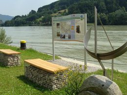
© Schlögener Schlinge (c) WGD Donau Oberösterreich Tourismus GmbH/GoodMorningWorld_MSchillinger
Schlögener Schlinge (c) WGD Donau Oberösterreich Tourismus GmbH/GoodMorningWorld_MSchillinger
search
Search
Close

Donausteig Stage 1_N02 Obernzell - Niederranna "Between the Danube and the High plateau"

  • culturally interesting
  • Multi-day tour

 Interactive elevation profile

Download GPS data
Create PDF

Tour-Details

Path number: Etappe 1_N02
Starting place: 94130 Obernzell
Destination: 4085 Hofkirchen im Mühlkreis

duration: 8h 0m
length: 23,3 km
Altitude difference (uphill): 694m
Altitude difference (downhill): 703m

Lowest point: 282m
Highest point: 636m
difficulty: difficult
condition: very difficult
panoramic view: Dreamtour

Paths covering:
Asphalt, Path / trail, Gravel, Hiking trail

powered by TOURDATA | Suggest a change

Short description:
The Donausteig-simply fabulous! On this stage, we follow the forested Durchbruchs­tal (valley) of the upper Danube - partly along the mighty Danube river, partly above on the rural plateau. We discover Obernzell as a jewel of the Danube, the highly demanded Passau porcelain clay, the frontier of upper bavaria, the natural jewel called the donauleiten, the importance of fishing in the middle ages...


Quality of experience: *****


Recommended season:
  • March
  • April
  • May
  • June
  • July
  • August
  • September
  • October


Properties:
  • Multi-stage route
  • Scenic
  • Refreshment stops available
  • Cultural/historical value
  • Geological highlights
  • Botanical highlights
  • Faunistic highlights


Seal of approval:
  • Quality route according to "Österreichisches Wandergütesiegel"

Description:
This Donausteig-stage starts in Obernzell. The historic Danube market is nestled in the wooded Gorge of ...
Starting point: Obernzell - the Donausteig "Obernzell" is located on the promenade at the same height of Castle Obernzell.
Destination: Niederranna - The Donausteig-starting place 'Niederrana' is located directly next to the ship dock 'Niederranna' (South of the Draxler Inn) Only reachable by foot!

further information:
  • Multi-day tour
  • Board possible

Accessibility / arrival

Getting there
Coming from the market place in Obernzell turn right the junction in front of the Castle Obernzell. Approx. 60m further on is the Donausteig-starting point on the right hand side  (Navi: D‑94130 Obernzell, Schloss Obernzell).

Public Transit
Obernzell can be reached by bus. Information on timetables online at www.vlp-passau.de. A transfer back form Niederanna is possible by bus as well. However, there is no direct direct connection and bus ride can take a few hours! Information on timetables online at http://www.ooevv.at  .

Parking
The city center of Obernzell is mainly a short parking zone. One can park free of charge along the walls of the castle Obernzell across from the dock of the Danube ferry or in the hostpial street.

Travelling by public transport
Route planner for independent travellers
  • Suitable for groups
  • Suitable for schools
  • Suitable for seniors
  • Suitable for single travelers
  • Suitable for couples
  • Suitable for children
Most economical season
  • Spring
  • Summer
  • Autumn

Please get in touch for more information.


Donausteig Stage 1_N02 Obernzell - Niederranna "Between the Danube and the High plateau"
WGD Donau Oberösterreich Tourismus GmbH
Lindengasse 9
4040 Linz

Phone +43 732 7277 - 800
mobile +49 5891 9116150
Fax machine +43 732 7277 - 804
E-Mail info@donauregion.at
Web www.donauregion.at
Web www.oberoesterreich.at/oesterreich-…
http://www.donauregion.at
https://www.oberoesterreich.at/oesterreich-stadt-ort/detail/430001152/pfarrkirchen-im-muehlviertel.html

We speak the following languages

German
English

 Interactive elevation profile

Download GPS data
Create PDF

Tour-Details

Path number: Etappe 1_N02
Starting place: 94130 Obernzell
Destination: 4085 Hofkirchen im Mühlkreis

duration: 8h 0m
length: 23,3 km
Altitude difference (uphill): 694m
Altitude difference (downhill): 703m

Lowest point: 282m
Highest point: 636m
difficulty: difficult
condition: very difficult
panoramic view: Dreamtour

Paths covering:
Asphalt, Path / trail, Gravel, Hiking trail

powered by TOURDATA | Suggest a change
Protected by