
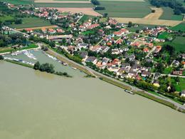
© © Tourismusverband Donau Oberösterreich | CM Visuals


Treasures & Delicacies
Naarn: Fuchtelmanderlweg Trail


- Suitable for families
- Flatly
- Possible accommodation
Interactive elevation profile
Create PDF
Tour-Details
Starting place: 4331 Naarn im Machlande
Destination: 4331 Naarn im Machlande
duration: 7h 30m
length: 27,9 km
Altitude difference (uphill): 99m
Altitude difference (downhill): 102m
Lowest point: 236m
Highest point: 333m
difficulty: medium
condition: medium
panoramic view: Great panorama
Paths covering:
Asphalt, Path / trail, Gravel, Other
powered by TOURDATA | Suggest a change
Short description:
Neuhof – Neuhofer Bridge – Hauswiesbrücke Bridge - Perg - Lanzenberg - Aisthofen - Altenhof - Au - Naarn
Neuhof – Neuhofer Bridge – Hauswiesbrücke Bridge - Perg - Lanzenberg - Aisthofen - Altenhof - Au - Naarn
Quality of experience: ****
Recommended season:
- April
- May
- June
- July
- August
- September
- October
Properties:
Description:- Loop
- Scenic
- Refreshment stops available
- Family friendly
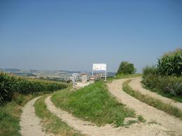
From the starting place in Naarn we cross the village and follow Perger Straße road. We cross the road, turn into Pratztrumer Straße road and keep the direction. We continue on the road past several farm houses and take a right turn at the next T-crossing. We follow this road and at a farm house we keep to the right and hike southwards. Near Baumgarten we keep to the left and ...
Starting point: Infopoint im Zentrum
Destination: Infopoint im Zentrum
further information:
- Flatly
- Possible accommodation
- Board possible


")
")

")
")
")
")
")
")

Accessibility / arrival
www.postbus.atParking
At Marktplatz square, at the guesthouses, public car park of the municipality of Naarn i. M.
Getting there
By car: A1 autobahn to “Enns-Steyr” exit or “St. Valentin” to Mauthausen respectively (Danube bridge) – federal road no. 3 to Perg – Naarn junction.
By train: The next train station is in Perg, 4km from Naarn.
By boat: Au/Danube landing stage
Public Transitwww.postbus.atParking
At Marktplatz square, at the guesthouses, public car park of the municipality of Naarn i. M.
Most economical season
- Spring
- Summer
- Autumn
Please get in touch for more information.
Perger Straße 2
4331 Naarn im Machlande
Phone +43 7262 58255 - 0
E-Mail gemeinde@naarn.ooe.gv.at
Web www.donauregion.at/naarn
Web www.donauregion.at
https://www.donauregion.at/naarn
http://www.donauregion.at
http://www.donauregion.at
")
Interactive elevation profile
Create PDF
Tour-Details
Starting place: 4331 Naarn im Machlande
Destination: 4331 Naarn im Machlande
duration: 7h 30m
length: 27,9 km
Altitude difference (uphill): 99m
Altitude difference (downhill): 102m
Lowest point: 236m
Highest point: 333m
difficulty: medium
condition: medium
panoramic view: Great panorama
Paths covering:
Asphalt, Path / trail, Gravel, Other
powered by TOURDATA | Suggest a change
Naarn: Fuchtelmanderlweg Trail
Suggest changes
Please let us know how we can improve the quality of this object or if there is any incorrect information on this page (eg. opening hours, contact, etc.).
Please fill in all fields marked *.