


Haibach: CICONIA-Loop Trail


- Flatly
- Possible accommodation
Interactive elevation profile
Create PDF
Tour-Details
Paths covering:
Schlögen - Inzell - Steiner Felsen vantage point - Rotes Kreuz - Schlögener Blick vantage point – Schlögen
Recommended season:
- April
- May
- June
- July
- August
- September
- October
- Loop
- Scenic
- Geological highlights
- Botanical highlights
- Faunistic highlights
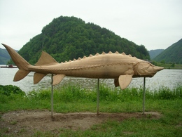
We hike along the approx. 10.5km-long CICONIA trail that features numerous stations and sculptures that tell about the unique landscape there.
Schlögen . Near the hotel complex is a excavation site datig back to the Romans (excavated west gate of the Ioviacum settlement that has been chartered around 440 A.D.). Our hike continues downstream the Danube along the Inzell carriage way to the village of of the same name, Inzell. There is ...
further information:
- Flatly
- Possible accommodation
Details - hiking
- themed path
- educational path
")


")

")
")
")

")
")
Getting there
By car: Westautobahn, “Linz” or “Wels” exit, towards Eferding, on the B130 towards Passau
By train: Linz or Wels main station, continue by bus towards Eferding – Haibach or Passau main station, by bus towards Linz
By plane: Linz/Hörsching airport
By boat: Schlögen boat landing stage
Public TransitBahn: Hauptbahnhof Linz oder Wels, weiter mit dem Postbus Richtung Eferding - Haibach nach Schlögen oder Hauptbahnhof Passau, weiter mit dem Postbus Richtung Oberösterreich / Linz – bis Schlögen
Schiff: Schiffsanlegestelle SchlögenParking
Große Parkflächen beim Hotel Donauschlinge
- Suitable for single travelers
- Suitable for friends
- Suitable for couples
- Spring
- Summer
- Autumn
Please get in touch for more information.
Kirchenplatz 4
4083 Haibach ob der Donau
mobile 677 61621401
E-Mail haibach@oberoestereich.at
Web www.donauregion.at/haibach
Web www.donauregion.at
http://www.donauregion.at
")
Interactive elevation profile
Create PDF
Tour-Details
Paths covering:
Haibach: CICONIA-Loop Trail
Suggest changes
Please let us know how we can improve the quality of this object or if there is any incorrect information on this page (eg. opening hours, contact, etc.).
Please fill in all fields marked *.