


Gemeinde Niederkappel
Niederkappel, Oberösterreich, Österreich


- All weather
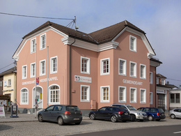
Municipal office
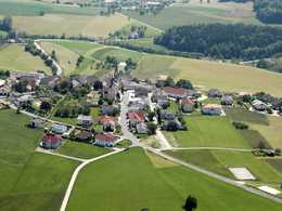
The municipality of Niederkappel lies on the south-eastern edge of the Donau-Ameisberg holiday region at 549 metres above sea level, covers an area of 22.45 km² and has around 1000 inhabitants. High above the Danube, at the exit of the famous Schlögener Schlinge, there are beautiful hiking trails with marvellous views.
The municipality of Niederkappel lies on the south-eastern edge of the Donau-Ameisberg holiday region at 549 metres above sea level, covers an area of 22.45 km² and has around 1000 inhabitants. High above the Danube, at the exit of the famous Schlögener Schlinge, there are beautiful hiking trails with marvellous views.
- opened daily
- open to the public
Closing day
- Saturday
- Sunday
- holiday
- Toilet facility
- Free entry
- All weather
Somewhat suitable for wheelchairs: Assistance is sometimes necessary. The measurements do not (fully) conform to the legally stipulated ÖNORM.
other information
- Toilet facility for disabled people
Contact
4133 Niederkappel
Phone +43 7286 8555
E-Mail gemeinde@niederkappel.at
Web www.niederkappel.at
http://www.niederkappel.at
Contact person
Mr Amtsleiter Daniel Paster
Gemeinde Niederkappel
Hauptstraße 12
4133 Niederkappel
Phone +43 7286 8555
Fax machine +43 7286 8555 - 30
E-Mail gemeinde@niederkappel.at
Web www.niederkappel.at
powered by TOURDATA | Suggest a change
Suggest changes
Please let us know how we can improve the quality of this object or if there is any incorrect information on this page (eg. opening hours, contact, etc.).
Please fill in all fields marked *.