


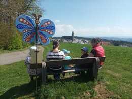
Schmetterlingswanderweg


- pets allowed
- All weather
- Suitable for families
- Suitable for kids (all ages)
- Flatly
- Possible accommodation
Interactive elevation profile
Create PDF
Tour-Details
Starting place: 4141 Pfarrkirchen im Mühlkreis
Destination: 4141 Pfarrkirchen im Mühlkreis
duration: 1h 45m
length: 5,9 km
Altitude difference (uphill): 145m
Altitude difference (downhill): 146m
Lowest point: 710m
Highest point: 850m
difficulty: medium
condition: medium
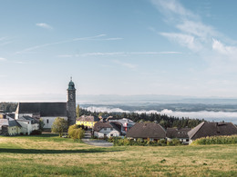
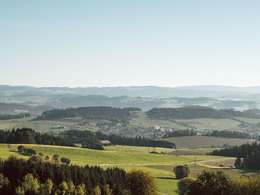
panoramic view: Great panorama
Paths covering:
Hiking trail
powered by TOURDATA | Suggest a change
Wonderful "panoramic" themed hike on forest and meadow paths around Pfarrkirchen.
At 20 stations, each marked with a butterfly, you can learn interesting and informative facts about the municipality and nature.
The ideal theme trail for families and school classes!
The start and finish is in Pfarrkirchen town square.
At 20 stations, each marked with a butterfly, you can learn interesting and informative facts about the municipality and nature.
The ideal theme trail for families and school classes!
The start and finish is in Pfarrkirchen town square.
further information:
- Flatly
- Possible accommodation
- Board possible
Details - hiking
- themed path
")
")
")
")
")
")
")
")
")
")
")
")
")
")
")
Parking
- Parking space: 30
- All weather
- Suitable for groups
- Suitable for schools
- Suitable for kids (all ages)
- Pets allowed
- Suitable for teenagers
- Suitable for seniors
- Suitable for single travelers
- Suitable for friends
- Suitable for couples
- Suitable for children
- Spring
- Summer
- Autumn
Please get in touch for more information.
Pfarrkirchen 13
4141 Pfarrkirchen im Mühlkreis
Phone +43 7285 415
E-Mail pfarrkirchen@oberoesterreich.at
Web www.donauregion.at/pfarrkirchen
http://www.donauregion.at/pfarrkirchen
Interactive elevation profile
Create PDF
Tour-Details
Starting place: 4141 Pfarrkirchen im Mühlkreis
Destination: 4141 Pfarrkirchen im Mühlkreis
duration: 1h 45m
length: 5,9 km
Altitude difference (uphill): 145m
Altitude difference (downhill): 146m
Lowest point: 710m
Highest point: 850m
difficulty: medium
condition: medium
panoramic view: Great panorama
Paths covering:
Hiking trail
powered by TOURDATA | Suggest a change
Suggest changes
Please let us know how we can improve the quality of this object or if there is any incorrect information on this page (eg. opening hours, contact, etc.).
Please fill in all fields marked *.