


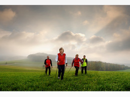
Aegidinger-Rundwanderung


- All weather
- Suitable for families
- Suitable for kids (all ages)
- Flatly
Interactive elevation profile
Create PDF
Tour-Details
Starting place: 4725 St. Aegidi
Destination: 4725 St. Aegidi
duration: 1h 30m
length: 6,0 km
Altitude difference (uphill): 101m
Altitude difference (downhill): 101m
Lowest point: 542m
Highest point: 604m
difficulty: easy
condition: easy
panoramic view: Great panorama
Paths covering:
Asphalt, Hiking trail
powered by TOURDATA | Suggest a change
After the western town sign "St. Aegidi", the Aegidinger Rundweg branches off to the left. A field and meadow path leads to Kößlau, crossing Sauwald Straße twice. Continue along field and forest paths to Steinedt. Shortly after the Steinedt goods road, turn right through a small wood to Höllau. After the village of Höllau, turn left onto the Reisedt estate road and after 250m turn left again onto a field path. The Keßla road only needs to be crossed and you come back to Lehen via a dirt track and back to St. Aegidi.
- All weather
- Suitable for schools
- Suitable for kids (all ages)
- Suitable for friends
- Suitable for couples
- Suitable for children
- Spring
- Summer
- Autumn
Please get in touch for more information.
Sankt Aegidi 10
4725 St. Aegidi
Phone +43 7717 7355 - 0
Fax machine +43 7717 7355 - 4
E-Mail gemeinde@st-aegidi.ooe.gv.at
Web www.st-aegidi.at
http://www.st-aegidi.at
Interactive elevation profile
Create PDF
Tour-Details
Starting place: 4725 St. Aegidi
Destination: 4725 St. Aegidi
duration: 1h 30m
length: 6,0 km
Altitude difference (uphill): 101m
Altitude difference (downhill): 101m
Lowest point: 542m
Highest point: 604m
difficulty: easy
condition: easy
panoramic view: Great panorama
Paths covering:
Asphalt, Hiking trail
powered by TOURDATA | Suggest a change
Suggest changes
Please let us know how we can improve the quality of this object or if there is any incorrect information on this page (eg. opening hours, contact, etc.).
Please fill in all fields marked *.