


Panorama-Wanderung


- Suitable for families
- Flatly
Interactive elevation profile
Create PDF
Tour-Details
Path number: 15 - Wanderweg
Starting place: 4090 Engelhartszell
Destination: 4090 Engelhartszell
duration: 3h 41m
length: 11,3 km
Altitude difference (uphill): 434m
Altitude difference (downhill): 434m
Lowest point: 289m
Highest point: 631m
difficulty: medium
condition: medium
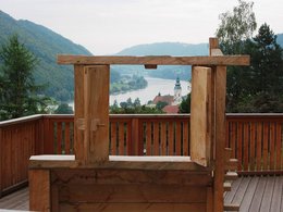
panoramic view: Great panorama
Paths covering:
Asphalt, Gravel, Hiking trail
powered by TOURDATA | Suggest a change
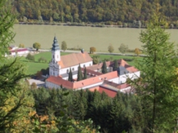
This hiking trail has the trail number 15. From the Engelhartszell market town hall, the path leads past the market church, uphill along the road, until it turns left into the forest after approx. 500 metres. Once you reach the main road at the top, walk past the rock on the left, over a small bridge and further uphill in the forest until you reach the panoramic viewpoint "Moarfelsen".
From there, the path leads into St. Aegidi, where you walk along the road on the footpath back towards Engelhartszell. After the sports centre, the path turns left to the Pamingerhof, then on to Zimmerleiten and then right to Mühlbach (trout circus).
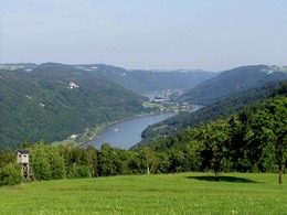
We walk up to the road, where we turn right and after approx. 200 metres turn left into the goods road to the panoramic view "Donaublick". Here you have a wonderful view of the Danube valley. We follow the farm track and then walk downhill through the mixed forest to the "Engelhartszell" panoramic stage and back to the starting point.
From there, the path leads into St. Aegidi, where you walk along the road on the footpath back towards Engelhartszell. After the sports centre, the path turns left to the Pamingerhof, then on to Zimmerleiten and then right to Mühlbach (trout circus).
We walk up to the road, where we turn right and after approx. 200 metres turn left into the goods road to the panoramic view "Donaublick". Here you have a wonderful view of the Danube valley. We follow the farm track and then walk downhill through the mixed forest to the "Engelhartszell" panoramic stage and back to the starting point.
- Suitable for groups
- Suitable for kids (10 - 14 Year)
- Suitable for single travelers
- Suitable for friends
- Suitable for couples
- Spring
- Summer
- Autumn
Please get in touch for more information.
Marktplatz 61
4090 Engelhartszell
Phone +43 7717 8055 - 16
E-Mail tourismus@engelhartszell.ooe.gv.at
Web www.engelhartszell.at
https://www.engelhartszell.at
Interactive elevation profile
Create PDF
Tour-Details
Path number: 15 - Wanderweg
Starting place: 4090 Engelhartszell
Destination: 4090 Engelhartszell
duration: 3h 41m
length: 11,3 km
Altitude difference (uphill): 434m
Altitude difference (downhill): 434m
Lowest point: 289m
Highest point: 631m
difficulty: medium
condition: medium
panoramic view: Great panorama
Paths covering:
Asphalt, Gravel, Hiking trail
powered by TOURDATA | Suggest a change
Suggest changes
Please let us know how we can improve the quality of this object or if there is any incorrect information on this page (eg. opening hours, contact, etc.).
Please fill in all fields marked *.