


Butterfly trail


- pets allowed
- All weather
- Suitable for families
- Suitable for pushchairs
- Suitable for kids (all ages)
- Flatly
- Possible accommodation
Interactive elevation profile
Create PDF
Tour-Details
Paths covering:
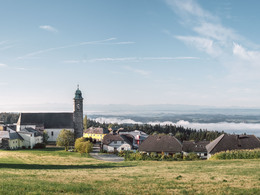
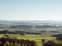
Wonderful "panoramic" themed hike on forest and meadow paths around Pfarrkirchen.
The ideal themed trail for families and school classes!
The start and finish is at Pfarrkirchen town square.
further information:
- Flatly
- Possible accommodation
- Board possible
Details - hiking
- themed path
Summer half-year
")
")
")
")
")
")
")
")
")
")
")
")
")
")
")
By car:
From Austria:
Autobahn A1 to Linz, from Linz on the B 127 to Altenfelden roundabout, turn off towards Lembach-Hofkirchen, continue to the turn-off to Pfarrkirchen
From Germany:
Autobahn A3 to Passau Nord. Take the B 388 towards Wegscheid until the junction to Oberkappel (border). From Oberkappel (crossroads) follow signs to Pfarrkirchen.
Train:
From Austria:
Mühlkreisbahn to Neufelden station, from there take a taxi (Heinzl company in Pfarrkirchen) to Pfarrkirchen.
From Germany:
Train station Passau, from there take a taxi (Heinzl in Pfarrkirchen) to Pfarrkirchen.
Airplane:
Airport Linz/Hörsching. From there by taxi (Heinzl company in Pfarrkirchen) onwards to Pfarrkirchen.
Boat:
On the Danube to the landing stage in Niederranna. From there, continue by taxi (Heinzl company in Pfarrkirchen) to Pfarrkirchen.
- Parking space: 30
- All weather
- Suitable for groups
- Suitable for schools
- Suitable for kids (all ages)
- Suitable for pushchairs
- Pets allowed
- Suitable for teenagers
- Suitable for seniors
- Suitable for single travelers
- Suitable for families
- Suitable for friends
- Suitable for couples
- Suitable for children
- Spring
- Summer
- Autumn
Please get in touch for more information.
Pfarrkirchen 13
4141 Pfarrkirchen im Mühlkreis
Phone +43 7285 415
E-Mail pfarrkirchen@oberoesterreich.at
Web www.donauregion.at/pfarrkirchen
Interactive elevation profile
Create PDF
Tour-Details
Paths covering:
Butterfly trail
Suggest changes
Please let us know how we can improve the quality of this object or if there is any incorrect information on this page (eg. opening hours, contact, etc.).
Please fill in all fields marked *.