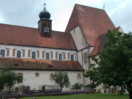
Baumgartenberg: Foothills of the Alps Views Loop Trail


- Flatly
Interactive elevation profile
Create PDF
Tour-Details
Paths covering:
Steindl - Amesbach - Mühlberg - Baumgartenberg
Recommended season:
- April
- May
- June
- July
- August
- September
- October
- Loop
We follow Donausteig Trail from the starting place in Baumgartenberg. We cross the forest after Amesberg and take a right turn before Sperken. We follow the course of the trail and take a left turn into the forest before the last farm. We keep to the right near Au and follow a side road towards Baumgartenberg that runs parallel to the main road. We cross the federal road and turn into a road in south-western direction. We follow the road to the starting point.Directions:
Vom Startplatz in ...
Public Transit
Train connection: Baumgartenberg train stationParking
Tennis court, municipal office, Kirchenplatz square
- Suitable for groups
- Suitable for single travelers
- Suitable for friends
- Suitable for couples
- Spring
- Summer
- Autumn
Please get in touch for more information.
Baumgartenberg 85
4342 Baumgartenberg
Phone +43 43 255
Fax machine +43 7269 255 - 5
E-Mail gemeinde@baumgartenberg.ooe.gv.at
Web www.baumgartenberg.at/
Web www.donauregion.at
http://www.donauregion.at
Interactive elevation profile
Create PDF
Tour-Details
Paths covering:
Suggest changes
Please let us know how we can improve the quality of this object or if there is any incorrect information on this page (eg. opening hours, contact, etc.).
Please fill in all fields marked *.


