


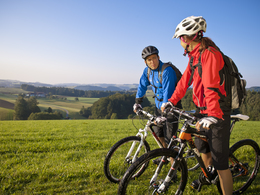
Donau-Moldau-Trail


Interactive elevation profile
Create PDF
Tour-Details
Path number: 3
Starting place: 4040 Linz
Destination: 38273 Vyšší Brod
duration: 5h 3m
length: 58,5 km
Altitude difference (uphill): 1.407m
Altitude difference (downhill): 1.096m
Lowest point: 253m
Highest point: 808m
difficulty: medium
condition: medium
panoramic view: Dreamtour
Paths covering:
Asphalt, Gravel
powered by TOURDATA | Suggest a change
North-south connection from Linz through the Sterngartl Gusental region to Vyšší Brod. Starting from Linz on the MTB route L1 towards Haselgraben, continue on hilly terrain on the north-south route no. 3 through the Sterngartl Gusental region (marked in both directions) to the Schwedenschanze border crossing. On the Czech side, follow the S8 signs to Vyšší Brod.
details mountainbike
- Riding technique: medium
Parking
- Parking space: 100
- Charging point for e-bikes (fees apply)
- Suitable for groups
- Suitable for single travelers
- Suitable for couples
- Spring
- Summer
- Autumn
Please get in touch for more information.
Ringstraße 77
4040 Linz
Phone +43 7213 20930
E-Mail office@sterngartl-gusental.at
Web www.sterngartl-gusental-leader.at
http://www.sterngartl-gusental-leader.at
Interactive elevation profile
Create PDF
Tour-Details
Path number: 3
Starting place: 4040 Linz
Destination: 38273 Vyšší Brod
duration: 5h 3m
length: 58,5 km
Altitude difference (uphill): 1.407m
Altitude difference (downhill): 1.096m
Lowest point: 253m
Highest point: 808m
difficulty: medium
condition: medium
panoramic view: Dreamtour
Paths covering:
Asphalt, Gravel
powered by TOURDATA | Suggest a change
Suggest changes
Please let us know how we can improve the quality of this object or if there is any incorrect information on this page (eg. opening hours, contact, etc.).
Please fill in all fields marked *.