


Ruins trail


- Suitable for families
- Suitable for pushchairs
- culturally interesting
Interactive elevation profile
Create PDF
Tour-Details
Path number: 112
Starting place: 4084 St. Agatha
Destination: 4084 St. Agatha
duration: 3h 15m
length: 11,8 km
Altitude difference (uphill): 213m
Altitude difference (downhill): 214m
Lowest point: 470m
Highest point: 605m
difficulty: easy
condition: very easy
panoramic view: Some Views
Paths covering:
Asphalt, Other
powered by TOURDATA | Suggest a change
Short description:
Mainly on meadow and forest paths with destination Stauf ruins. St. Agatha-Stefan-Fadinger-Hof-Ruin Stauf.
Mainly on meadow and forest paths with destination Stauf ruins. St. Agatha-Stefan-Fadinger-Hof-Ruin Stauf.
Technique: *
Quality of experience: ***
Recommended season:
- March
- April
- May
- June
- July
- August
- September
- October
- November
Properties:
- Scenic
- Family friendly
- Cultural/historical value
- Geological highlights
- Botanical highlights
- Faunistic highlights
- Suitable for strollers
Tip:
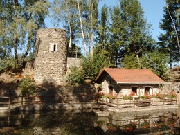
ruins history
Starting point: St. Agatha center
Destination: St. Agatha center
further information:

.JPG (© Alois Ferihumer)")
Accessibility / arrival
Parking
Parking possibilities
Public Transit
Location and getting there
How to arrive in the Danube Upper Austrian region?
The fast way to your destination – by train, bus, car, boat or plane.
Parking
Parking possibilities
- Suitable for pushchairs
- Spring
- Summer
- Autumn
- Early winter
Please get in touch for more information.
Kirchenplatz 1
4083 St. Agatha
Phone +43 7277 8255 - 0
E-Mail gemeinde@st-agatha.ooe.gv.at
Web tourismus.st-agatha.at
https://tourismus.st-agatha.at
Interactive elevation profile
Create PDF
Tour-Details
Path number: 112
Starting place: 4084 St. Agatha
Destination: 4084 St. Agatha
duration: 3h 15m
length: 11,8 km
Altitude difference (uphill): 213m
Altitude difference (downhill): 214m
Lowest point: 470m
Highest point: 605m
difficulty: easy
condition: very easy
panoramic view: Some Views
Paths covering:
Asphalt, Other
powered by TOURDATA | Suggest a change
Suggest changes
Please let us know how we can improve the quality of this object or if there is any incorrect information on this page (eg. opening hours, contact, etc.).
Please fill in all fields marked *.