


Danube view trail - sporting day hike


- Flatly
Interactive elevation profile
Create PDF
Tour-Details
Starting place: 4133 Niederkappel
Destination: 4133 Niederkappel
duration: 4h 9m
length: 13,5 km
Altitude difference (uphill): 546m
Altitude difference (downhill): 545m
Lowest point: 281m
Highest point: 618m
difficulty: medium
condition: difficult
panoramic view: Some Views
Paths covering:
Asphalt, Other
powered by TOURDATA | Suggest a change
Short description:
Explore Niederkappel across hills and river landscapes
Explore Niederkappel across hills and river landscapes
Technique: ***
Quality of experience: ***
Recommended season:
- March
- April
- May
- June
- July
- August
- September
- October
- November
Properties:
- Loop
- Scenic
- Refreshment stops available
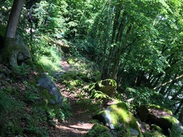
Challenging circular trail with several sharp climbs through a varied region through the Danube and Mühltal valleys with beautiful views
Equipment:
Hiking shoes are definitely recommended
Starting point: Niederkappel local square, Gierlinger guest house
Destination: Niederkappel local square, Gierlinger guest house
further information:
- Flatly
- Board possible
")
")
")
")
")
Accessibility / arrival
Public Transit
Parking
village centre
Getting there
From Linz on the B127 to Altenfelden roundabout, turn-off to Lembach im Mühlkreis, follow the course of the road to Niederkappel.
Public Transit
How to arrive in the Danube Upper Austrian region?
The fast way to your destination – by train, bus, car, boat or plane.
Easily reached from Linz by public bus in a good hour.
Parking
village centre
Most economical season
- Spring
- Summer
- Autumn
- Early winter
Please get in touch for more information.
Hauptstraße 12
4133 Niederkappel
Phone +43 43 7277 - 800
Fax machine +43 732 7277 - 804
E-Mail gemeinde@niederkappel.at
Web www.donauregion.at/niederkappel
https://www.donauregion.at/niederkappel
Interactive elevation profile
Create PDF
Tour-Details
Starting place: 4133 Niederkappel
Destination: 4133 Niederkappel
duration: 4h 9m
length: 13,5 km
Altitude difference (uphill): 546m
Altitude difference (downhill): 545m
Lowest point: 281m
Highest point: 618m
difficulty: medium
condition: difficult
panoramic view: Some Views
Paths covering:
Asphalt, Other
powered by TOURDATA | Suggest a change
Suggest changes
Please let us know how we can improve the quality of this object or if there is any incorrect information on this page (eg. opening hours, contact, etc.).
Please fill in all fields marked *.